Continuing my Tripoint in Europe project, I once again ventured into the depths of central Europe. After escaping the office, I went by train to Poland, where my secondary objectives were to visit
Gdańsk,
Wrocław and
Krakow. The primary objective was to reach the tripoint between
Poland, the
Czech Republic and
Slovakia.
Accessing the actual tripoint is easy by car if you come from the Polish side, however if you use public transportation things may need a little planning.
View Larger Map
Initially my plan was to leave Krakow early, and go by train to the Slovakian village
Skalite, which apparently is the closest spot with some sort of accommodation - I thought it would be too stressful to attempt to do it in one day.
Just in case, I attempted to reserve a room at
Hotel Kolonial. I was a bit worried I might end up in Skalite with no trains, no taxis and no place to stay. Tried to call them:
- "English?"
- "No."
- "Deutsch?"
- "No."
- "Po Russki?"
- "No."
- "Uhh...."
- "Iba slovenské alebo poľské."
- "Alright...."
- "Send email, ok?"
- "Ok, right. Dakujem."
Which I did, but no response came. Then I had a polish friend calling him, all seemed ok, had to SMS the details. Ok. No reply. Guess it's ok then, I'm just stressing out.
Next thing was to arrange travels to Skalite. Idea was to go from
Krakow to
Zwardon (a small Polish village just at the border to Slovakia). Now, In
Wrocław there was a
beautiful new renovated train station, so I might just get the tickets right away, again with some help from friends.
The "administrative system" inside the nicely renovated train station clearly has not been renovated: going to the domestic ticket booths, there were three queues to choose from. The first one I took, was wrong: "This company does not service Zwardon. Go to next booth."
Re-queue in another line. I earlier wrote down the connection details which I found on
www.bahn.de.
- (Showing paper saying my destination.) "Zwardon."
- "Gdzie?"
- Oh, sorry, I spelled it wrong, "d" was missing. (I could swear I thought I got it right.)
- Aha. (Pause.) No.
- No?
- That connection is not possible.
- Uh-um...
Anyway, after retrying in Krakow, it turned out my idea to go all the way by train (yeah, I love trains ) seemed to be a stupid idea. Instead of a 6-hour ride, one can take a 1-hour ride with bus from Krakow to
Żywiec (which hosts
a major Brewery, therefore known by all locals and beyond). In Żywiec then there is a local train to Zwardon and from there ... well if all fails, my destination for the night Skalite is just 5-7 km further, so I might just walk.
I left Krakow by bus departing from the bus terminal behind the main train station around noon. The weird thing about that ride was the crazy amount of furniture shops in the villages. It was like 60% of all shops specialized in selling furniture, very surreal.
Arriving in Żywiec there was again plenty of time to get the ticket for the next part. "Do Zwardon." "Dwe?" "Tolka odin". Languages are kind of weird. Young people are good at English, elderly more into German, and then there is a group of people who know neither. The five words of Russian I know come in very handy here, even though I was told that some people may be a annoyed if you approach them with Russian. But what else could I do.
 |
| In Zywiec (Poland), waiting for my train connection to Zwardon, which is located just at the Polish-Slovakian border. |
The train ride to Zwardon was another 1-2 hours, partially nice landscapes and cute small villages. The amount of furniture shops seemed to reduce again to normal levels.
 |
| Somewhere halfway between Zywiec and Zwardon in Poland. |
The train ended in Zwardon, and then I was faced with the questions on how to get to the village Skalite. A Slovak train was standing ready on the next platform in Zwardon, going to Zilina, however I could not figure out when it was supposed to leave. It was already 15:30, and I was worried it might get dark before I can reach the triplex point, which is another 5 km from Skalite. This would be my only chance to do it, next day I must leave early in order to catch my flight home from Vienna.
 |
| Zwardon, just 200 m from Slovakian border. |
This brought me into a dilemma, either walk fast those 7 km, (not sure if there is a path all the way), or take the train whenever that leaves. A very friendly Slovakian train conductor was at the site, me trying to communicate in numerous languages with assisted/augmented hand waving. She knew some words in German - "Langsam, bitte!" (same thing I say when someone races off in one of the Slavic languages "Ne bistra!"). A pen and piece of paper did it - train would leave in 30 min.
- "Setzen Sie sich."
- "Ja ja."
View Larger Map
In these small villages there are no places where train tickets can be bought, at least none which are open. Train tickets can instead be bought on the train. I paid 0.48 € for Zwardon - Skalite. On the ~6 km ride, the train stopped 3 times before reaching Skalite. Felt strange.
Arriving at
Hotel Kolonial - it was open indeed and I was the only guest it seemed. I quickly checked in, paid 20 € and grabbed my gear for the hike to the tripoint. It was raining cats and dogs, but then quickly cleared.
 |
| Skalite. Facing north, Poland is just behind those hills. |
 |
| One of the countless train stations named Skalite-something. The train stops every 1 km it seems. |
The first km you just follow the train tracks to the west. A small tunnel will then take you to the northern side of the road, follow this and you will pass some housing while you leave the train tracks behind you.
 |
| Entering Čierne-Polesie. |
As you exit the village, the road will take you over a small hill and then bring you past a piggery. There might be some signs saying no trespassing, I was not too sure. The gate was open and no one was bothered by my presence. Just after it, you cross a bridge over a small river
Čierňanka, and then you are on a marked hiking path. The marks are deceptive though, if you want to reach the tripoint area you must at some point leave the marked path.
You will cross some open terrain and bits of forest, and soon the path follows more or less the Slovak-Polish border. I used the
MapDroyd app on my mobile for navigation. Several paths are missing in
open street maps, but it is still easy to navigate by just following the general direction.
 |
| The crappy GPS antenna of my HTC Desire S was driving me nuts. Could only get a lock in open terrain with no clouds. Got myself a Nexus 4 now. Heaps better, and includes russian GLONASS. Works even inside my flat, so I won't get lost at home any more. |
 |
| This side: Slovakia. Other side: Poland. |
The path took me back to the Polish side. Now outside the forest, I was rewarded with a wonderful view.
 |
| Poland, facing north. |
 |
| Facing east, forest to the right is in Slovakia, everything else is in Poland. |
 |
| In Poland, facing west. Forest to the left is in Slovakia, the distant hills are in the Czech republic. |
Following the path on the Polish side, the actual tripoint area comes into view.
 |
| Poland. Hill to the left is in Slovakia. The little roof is already in the Czech republic. |
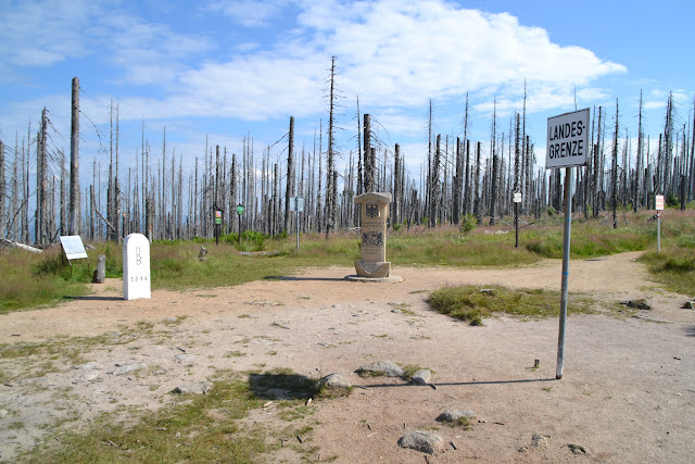
The area is void of people, but at the tripoint there are facilities to BBQ on either the Czech or Slovak side. Again some monoliths were placed at each country corner, however the actual tripoint is rather hidden.
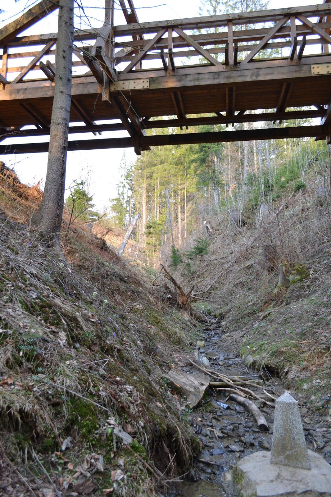
The Czech and Polish side is on the same side of a small creek which separates Slovakia. A bridge was build where you can cross the creek and go to the Slovakian side.
 |
| Ah! What is that to the right? Is that it? Is that it?! Yes?! |
 |
| Huh? A cross, not a triangle? What is this? No...?! I got it all wrong! |
Where is the real tripoint? In fact, I only realized after I crossed the bridge that something isn't right. There were plenty of these red and white landmark stones scattered around with more or less random marks on, something didn't make sense here.
 |
| On the Polish side, seeing the Skovak BBQ place. |
The key is the bridge, if you stand on it and look down the western side you may find a small landmark in the middle of the shallow creek.
That's it! Climbing down....
 |
| There! The triplex point of Poland, Czech Republic and Slovakia. |
 |
| Wonder if it can be moved? |
In fact, it's kind of a dull place, didn't stay there too long.
 |
| Tadaa! |
Well then... Made it! Primary objective of my central Europe trip completed! :-) From the hotel in Skalite it took me roughly 1-2 hours to get here.
 |
| Yup! |
Extensive information on the area is provided by billboards in Polish, Czech ans Slovak.
 |
| Trojmezi alright! |
 |
| Yes, this area is void indeed. |
Didn't eat much this day, nearly starving, I could now go back to the hotel (went off the paths a few times on the way back: bad idea, I can assure you). At the hotel, the owner was gone and hotel was locked. My key didn't fit. while waiting, I met a friend of the owner, Fero, (who spoke some German) and a bit later the owner, Karol (who is fluent in Slovak and Polish), came back.
There are no restaurants in Skalite apart of the hotel, and that one is only open at noon. Karol offered to cook me a Schnitzel... perfect! What a Schnitzel! I cant remember I ever enjoyed one so much!
 |
| Best Schnitzel I've ever had. Period. |
Rest of the evening went hanging out with Fero and Karol. Karol was a virtuoso on the
Fujara, a Slovakian didgeridoo kind of thing.
Well... guess I am just as good as playing that instrument as Karol is taking photographs of me playing it. Other way round seems to work better.
Several people (and Slivka) from the neighborhood joined afterwards. Ended up singing a Slovak folk song (the only one I knew -
V hlbokej doline - they all tuned in, impressed :-). Made good friends with Fero's son Juraj who took me early next morning to Zilina railway station. From here, the rest of the trip was trivial. I continued to Bratislava where the airport bus took me to Schwechat
Vienna airport. Certainly, I got a favorite country in Europe, this place is highly recommended.
Album from the tripoint visit
here.
Coming up soon: How to (re)claim small amounts of your country by secretly displacing landmarks in the wilderness.
Update: Lyrics and translation to
V hlbokej doline, thanks again, Juraj!
1.
[:V hlbokej doline srnka vodu pije,:]
[:horár na ňu mieri, horár na ňu mieri,
horár na ňu mieri, že si ju zastrelí.:]
2.
[:Nestrieľaj ma horár, neni som ja srnka,:]
[:ale som ja, ale, ale som ja, ale,
ale som ja, ale, zakliata panenka.:]
3.
[:Zakliala ma mamka v nedeľu za rána,:]
[:že som nechcela ísť že som nechcela ísť,
že som nechcela ísť, za pána horára.:]
4.
[:Horári, horári, zle horárujete,:]
[:za každou jedličkou, za každou jedličkou,
za každou jedličkou dievča milujete.:]
5.
[:Horárova žena bledá ako stena:]
[:a horár červený, a horár červený,
a horár červený, ľúbi iné ženy.:]
Approximate translation
1.
In deep valley doe drinks water,
Hunter aims on her,----//----
Hunter aims on her, to shoot her
2.
Don't shoot me a hunter, I am not a doe
but I am, but i am, but
but I am, cursed young girl.
3.
My mother cursed me on Sunday morning.
because I didn´t want to marry, ----//----
because I didn´t want to marry, marry with hunter.
4.
hunters, hunters, you are bad hunting
behind every tree,-------//-----------
behind every tree, you are loving a girl.
5.
hunters wife is pale as a sheet
and hunter is red in face, -----//--------
and hunter is red in face, cause he loves other women.
---