Опасная зона

Опасная зона
Showing posts with label Austria. Show all posts

Sunday, August 2, 2015

Tripoint Borders V: Germany, Austria and Czech Republic

Summer 2015 I visited two new tripoints, this post will cover the one at the German-Austrian-Czech border.


The tripoint is older than the Czech Republic, as it bordered to Bohemia, until Czechoslovakia was created after the 1st World War. For centuries it used to be an "open" border, which could freely passed, but after the second world war, the iron curtain prevented any free passage for more than 40 years. Today it is again an open border with many hiking trails.

[Short video covering the tripoint visit.]

I went there first by staying a night in Passau, followed by a bus ride to Haidmühle in Bavaria. I was worried whether I could find accommodation there, but it turned out to be a hiking hotspot with plenty of hotels and Bed&Breakfast Inns, with many recurring visitors.

Or... it used to be.
Today, business is not going well at all and most B&Bs are closed. Locals told me that tourism peaked while the iron curtain border was still there, but once the borders opened, most tourists went to the cheaper Czechoslovakia / Czech Republic side instead. At the same time the village Haidmühle failed to attract new generation of customers. I noted that even in Google maps only a few the many B&Bs appear, and to our generation ... well, if it is not in the internet, it does not exist.

Anyway, the landlady of the B&B where I stayed took me halfway to a parking lot at the Dreisesselberg, some 3 km from the tripoint. From there on can find two hiking trails which lead to the tripoint. I took the northern one, as it follows the top of the hills and was a bit quicker, and - most interestingly - the road is following the Czech-German border exactly. Buying a hiking map is strongly recommended, also if you wish to investigate the surroundings.


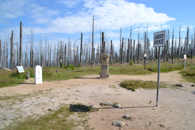
Starting at 9:00 am I did hardly meet anyone on the way to the tripoint. There used to be a forest there, but very recently it died, for reasons unknown to me. This gave the hike some kind of post-apocalyptic feeling.

Hiking trail following the Czech-German border, some 2 km from the tripoint.


Czech-German border stone markings carry the "D" for "Deutschland" and "B" for Bavaria, barely visible.
After hiking 50 minutes or so, I could see the tripoint appearing in a small open valley.

Tripoint ahead!


The tripoint seen from Czech side, behind it and extending to the right is Austria.
The Czech border stones had added a "S" for CzechoSlovakia, which are still visible. However today only the C is updated.

Tripoint seen from Austrian side, Austrian sign warning for the border. Germany to the left of the tripoint and Czech Republic to the right.


Similarly a warning sign on the Czech sides. Beware, those Pozors should not be fed, they will bite you.

Sign from German side. Apparently Germans are less inclined to say "Achtung" than Austrians are.
I am surprised.
Close up of the tripoint top. Carefully placed markings show the division of the three countries. Below is Czech Republic, to the left we have Austria, the smaller triangle to the top right is Germany.

"The foot in Austria,
the other in Bohemia,
the heavyweight in Bavaria,
it can only happen at the Dreisesselberg."


Possibly, this was not the most spectacular tripoint I have seen. Much nicer was the nearby German-Czech border at Nové Údolí where there is a small museum covering the iron curtain times.
This will be covered in another post. :)

Full tripoint gallery here.

Wednesday, January 25, 2012

Tripoint Borders II: Slovakia, Hungaria and Austria

After the first tripoint border post where Germany meets Poland and the Czech republic I will now go a bit further south. Summer 2011 I visited colleagues in Bratislava, and took a look on a primary standard dosimetry laboratory. I stayed in a little village south of Bratislava called Čunovo [Tschoo-no-vo]. I knew the Austrian border was just a few kilometers upstream the Danube river, but what I did not realize was, how close I was to the Hungarian border as well. It was just a few 100 meters away, which I found out when I got back to Aarhus, and checked my maps. The border tripoint was just 2 km east.
I missed it, unknowingly. Bummer.

Bad luck, but fortunately I got a second chance. In November I was in Čunovo again, and I convinced my friends to take me to the border tripoint (they've been living 20 years in Čunovo, but have never vistied the tripoint themselves. How can anyone be not as geeky as me?).


View Tripoint: AT, SK, HU in a larger map

So we took their dog for a walk (a black and rather friendly minded Labrador, who occasionally reacts on the name "Arwi" and to various goodies).
Eva, Tibor and Linda (who doesn't live in Čunovo, but Melbourne, Australia - the country WITH kangaroos), clearly thinking "why do we have to go here, where is he taking us". Arwi, the friendly black Labrador, is obviously fine with it.

The Hungarian-Slovakian border was interesting, a true prototype checkpoint, almost taken out of a Tintin Hergé comic.

Just crossed the border, this is on the Hungarian side, facing north, to Slovakia. The checkpoint building seemed to be unoccupied for years. In the electric lines over the rail tracks to the left there is a small square sign which indicates an upcoming interruption in the power supply. Yeah, I pay attention to such weird details.

I've only been once to Hungary during the solar eclipse in 1999, (Kiskunhalas, a real tourist trap!). Language is totally incomprehensible, here I am obviously approaching the "Magyar Köztársagág".


Yeah, Köztársaság, bring it on!

.

Half of me in Slovakia, other part in Hungary. (Clothes borrowed from Tibor, thanks. Linda spilled carbonated drinks all over me in the plane to Vienna and I smelled like a brewery.)

Sun setting in the west (no kidding), along the Slovak/Hungarian border. Austria (that country WITHOUT kangaroos) at the horizon.
The countryside is flat, almost "Nordfriesland" like (close to where I grew up), which is also pan-cake flat like. Just without the sheeps and cattle. And the sea. And the miserable gray weather.

After a 20 min walk we reached the tripoint.

That's it! The white pillar marks the tripoint. Standing in Austria "Ö" (NO kangaroos), facing east, Hungary "M" to the right, Slovakia in the background.

Triplex point.
Very little was left from the original border from the pre-Schengen era.

A piece of the original barbered wire fence between Slovakia and Hungary.
Around the tripoint a few art installations could be found. Various rocks were scattered around, shaped and piled in different ways. In the left side of the picture above you may recognize a flat rock. I have no picture of its surface, but it was triangular with many alien-like hieroglyphs across it.

Update: got it (thanks again, Tibor)...
 
Hmm..?
There seems to be some kind of link between Bratislava and aliens. Think also of the top restaurant of the "Novy Most" (= "new bridge") over the Danube: it is UFO shaped, and I'm sure it can detach from the bridge if necessary. (:)|-<

Navigation aid for aliens. Get the idea? I feel a conspiracy uncovering.
The (still friendly minded) Labrador Arwi was more into chasing rabbits in the fields. Both the rabbits and Arwi crossed borders multiple times during the chase, underlining that borders are a creation of human minds, not of those of dogs and rabbits (or aliens).

There are "Pozor"s in the field. Beware.


Certainly worth going there, so thanks to Eva, Tibor and Linda for being patient with me, and Arwi for being the friendly black Labrador she is.
(Arvi missing, found another rabbit.)

All photos made with crappy mobile phone camera, more weird photos may be discovered here.