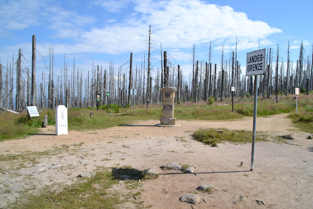
The tripoint is older than the Czech Republic, as it bordered to Bohemia, until Czechoslovakia was created after the 1st World War. For centuries it used to be an "open" border, which could freely passed, but after the second world war, the iron curtain prevented any free passage for more than 40 years. Today it is again an open border with many hiking trails.
[Short video covering the tripoint visit.]
I went there first by staying a night in Passau, followed by a bus ride to Haidmühle in Bavaria. I was worried whether I could find accommodation there, but it turned out to be a hiking hotspot with plenty of hotels and Bed&Breakfast Inns, with many recurring visitors.
Or... it used to be.
Today, business is not going well at all and most B&Bs are closed. Locals told me that tourism peaked while the iron curtain border was still there, but once the borders opened, most tourists went to the cheaper Czechoslovakia / Czech Republic side instead. At the same time the village Haidmühle failed to attract new generation of customers. I noted that even in Google maps only a few the many B&Bs appear, and to our generation ... well, if it is not in the internet, it does not exist.
Anyway, the landlady of the B&B where I stayed took me halfway to a parking lot at the Dreisesselberg, some 3 km from the tripoint. From there on can find two hiking trails which lead to the tripoint. I took the northern one, as it follows the top of the hills and was a bit quicker, and - most interestingly - the road is following the Czech-German border exactly. Buying a hiking map is strongly recommended, also if you wish to investigate the surroundings.
Starting at 9:00 am I did hardly meet anyone on the way to the tripoint. There used to be a forest there, but very recently it died, for reasons unknown to me. This gave the hike some kind of post-apocalyptic feeling.
 |
| Hiking trail following the Czech-German border, some 2 km from the tripoint. |
 |
| Czech-German border stone markings carry the "D" for "Deutschland" and "B" for Bavaria, barely visible. |
 |
| Tripoint ahead! |
 |
| Tripoint seen from Austrian side, Austrian sign warning for the border. Germany to the left of the tripoint and Czech Republic to the right. |
 |
| Similarly a warning sign on the Czech sides. Beware, those Pozors should not be fed, they will bite you. |
 |
| Sign from German side. Apparently Germans are less inclined to say "Achtung" than Austrians are. I am surprised. |
 |
| "The foot in Austria, the other in Bohemia, the heavyweight in Bavaria, it can only happen at the Dreisesselberg." |
Possibly, this was not the most spectacular tripoint I have seen. Much nicer was the nearby German-Czech border at Nové Údolí where there is a small museum covering the iron curtain times.
This will be covered in another post. :)
Full tripoint gallery here.


